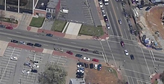
What would you think if the government was recording live satellite video imagery of the entire USA, up close? What if a crime was committed but wasn’t discovered till later on? The government could literally rewind time and track the entire path of the escape vehicle, leading to the arrest of the perpetrator.
According to the wikipedia, the USA is approximately 3,718,711 square miles in size.
Using these numbers, if you were to take the USA and squeeze it into a flat, square shape,it would be approximately 1,928 miles in width and 1,928 miles in length.
If you were to photograph the USA at 431,309,824 pixels per square mile (approximately three times higher resolution than current internet satellite/aerial imagery gives you), then you would use 1,603,257,976,815,616 pixels to photograph the entire USA.
If we saved this image off without compression as a 2 bytes per pixel image, then the file size would be 3,206,515,953,631,232 bytes, or around 2,917 terabytes in size.
With a typical compression algorithm, you could theoretically get it down to around a third of that size… probably around 960 terabytes.
Now, let’s theoretically record this area at 30 frames per second. At first glance, you’re probably thinking, “whoa! 28,878 terabytes a second???”. But you have to remember that this would be video you’re dealing with. A good video compression algorithm would only record the differences between frames. And trust me, a TON of those pixels aren’t going to change noticeably in that small space of time. Pretty much all you’d be recording would be people and vehicles moving across the face of an otherwise static and unchanging image. So let’s just say that less than 1% of that square mileage would appear to have moved at all.
Which means you’d probably have less than 5 terabytes worth of image differences per frame. At this estimate, 1 second of video would only take up around 150 terabytes (not 28,878). This means that we could record the USA at 540,000 terabytes per hour. Assuming that we took a complete snapshot of the entire USA every single hour (960 terabytes), then 24 hours of the USA would take up around 12,678 petabytes.
This may sound like a completely absurd size, but it’s not so mind-numbing when you think about the new holographic data storage technologies that are being developed right now. Terabytes will be cheaper than megabytes are now.
What if they only recorded major cities for now, and they were to do it at only, say, 5 frames per second? Or even just one frame per second for starters? They could still track vehicles and do basic surveillance.
In the mean time, check out this massive 18,000×18,000 pixel image that was taken by the Hubble telescope!
If you like this post, digg it!
21 responses to “Satellite Imagery/Video of the USA from space”
that’s a lot of math tom 🙂
Yeah. Well, I never finished preschool so the numbers might be off a little bit.
Wow.
Having a slow day there at Tornado, huh?
; )
haha… No not really. This was a result of a long conversation over 8 shots of espresso between chris and I the other day.
Yikes.
You should go for 10 shots and see if you can prove Fermat’s last theorem.
Mark – that’s going to be REALLY easy. I’m sure I can do it. I’m not sure how Fermat’s last theorem fits into this (I read a little bit about this and don’t get how it is related) but ten shots of espresso is going to be as simple as [insert your favorite euphemism here].
In fact, when we had the 8 shots the other day I dared Tom that I could do twelve but he declined. I’ll tell you, I was asleep and in bed by 10 pm. It had almost no effect except to make me really bad at Battlefield 2.
Chris –
I was just smarting off with a bit of sarcastic, dry wit that was apparently lost in translation.
If 8 shot of expresso motivates you boys to tackle heady issues like trillions of pixels and petabytes, then maybe 10 shots would boost your brain power to figure out string theory or some such issue.
Mark – I get it now. It must have been the espresso. Ever since I had it I’ve been in a daze.
Dude, NSA sucks in every signal it can get its hands on and records it. Pirating signals even. So what you’re saying here isn’t just conceivable, it’s in the very likely realm of possibility.
I’m pretty sure that a lot of real-time satellite video is being shot as we speak, though I don’t know if the USA is the primary target. However, what with 9/11 and all, there’s probably some domestic video coverage going on too.
Great post BTW, lots of fun to read!
Tapestry™, Holographic Video Storage…
It’s funny, I was thinking about this just this morning. It seems like InPhase Technologies has built a Holographic Video Storage system (link via Brainfuel). I first saw this tech on 3-2-1 Contact over 10 years ago. At the time the media they we…
Hmm. Interesting math, but some real practical issues:
Currenty the entire world wide internet only runs at few terebytes per second. And most of that is wired.
There doesn’t currently exist a wireless technology that would be capable of streaming that much data down from the satellite in real time. Especially if the satellites are in geo-synch orbit, where you need a lot of power to punch a signal all the way to earth. I’m not a signal expert, but you may end up needing to flood the earth of RF spectrum signals just to try and keep up with the stream. We would need to look at other transmission technologies to get it to work (Lasers?).
As an aside, you might be able to just store the data on the satellite’s themselves, and only download pics that are requested. So most of the data is overwitten after a few days or weeks. Not perfect but more practical.
Also, satellite images aren’t that perfect, and are often blocked by clouds. (Ever notice how it’s always sunny everwhere on Google Earth shots?)
However if security is your goal, then you may want to try and reduce your image to just major urban areas (which make up most of the crime in the US). That might slash your image size down to about 15-20% of the size (why waste all those expensive pixels on empty deserts and mountain ranges?)
Also LEO (Low Earth Orbit) satellites would probably be preferred, since they are more likely to take an “overhead” shot, unlike Geo-Synch which would always take a “angled” shot and deal with more tree and building obstructions. But LEO’s move, and aren’t over the same spot at any one moment, so you need multiple satellites to get it to work (Siruis radio uses 3 LEOs, XM uses 1 GeoSynch). But LEOs are also closer to the earth, so they are capable of higher bandwidth transmission using the same power strength.
There is some cool effort going on trying to create blimps that run on auto-pilot and fly very high (Higher than all the commercial aircraft) and could have all sorts of transmission and survielence technology. They can stay flying for weeks without landing. You could just hang one of those over every major urban area and get something very close to what you are talking about.
Damn. I’ve become the lapdog of big brother.
hey guys try 20 shots then see if you can figure out the harddrive space needed to cover the whole world including different zoom settings and different pan and tilt options
digg it!
goog idea
download
Do you really think you know what is going on in “Top Secret land”?
Let me tell you something.
In approx 1973-74, Reader’s Digest had an article about US satellite capability (AT THAT TIME). The article indicated that the US had the ability to identify the numbers of a vehicle license plate & the person driving it from miles up in space from that satellite.
That was 34 years ago!!
Do you really think that was there best capability back then? Or was it only what they were willing to admit to at that time.
Since it has been 30+ years since then don’t you think that what we are allowed to see on the internet does not even come close to what our government is capable of doing?
If I were the government in 1974 I would have bragged about something like being able to see your lisence plate from space too 😉 Doesn’t mean they weren’t streeeetching the truth a little bit, you know…to sound cool for the people.
Hmmm, geekapalosa – US Spy Satelites have been operational
with amazing clearity since the mid 1960’s.
Thats fourty years of technology multiplied by whatever the average advancement is…. so now we can view bacteria from space making little babies. No more privacy.
this shit is shit
The cars arent moving………
Check out this real world implementation of this idea:
http://www.extremetech.com/extreme/146909-darpa-shows-off-1-8-gigapixel-surveillance-drone-can-spot-a-terrorist-from-20000-feet